Land Drainage and Westonzoyland Pumping Station

Iain Miles gave a fascinating and detailed talk in February about the Land Drainage of the Somerset Levels and the importance of Westonzoyland Pumping Station.

He introduced the subject 
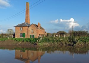
by setting it in a landscape context. He explained how the basin at the heart of the Somerset Levels is surrounded on three sides by high ground in the form of Exmoor, the Brendons, the Blackdowns, the Poldens and the Mendip ridge. The rivers originating in these hills flow into the basin and most join the Parrett to flow into the sea to the north of Bridgwater. The silt from these rivers has been deposited in the basin over millennia and the area as we see it today is a flat or level surface rarely more than 10ft above OD and with only a very small gradient on its rivers once they leave the hills. The character of the area and its tendency to flood is therefore partly due to the effect of heavy rainfall on the hills and the inability of the rivers to transport water quickly to the sea, but also to the high tidal range in the Bristol Channel. At times of high spring tides, the sea can penetrate inland and overwhelm a river system struggling to transport its load to the sea. Clyses or tidal doors have been constructed to prevent the sea from penetrating inland and the earliest of these to be documented is the Highbridge Clyse recorded as being already in existence by 1485.

For many years the area was largely uninhabited. Only small islands punctuated what was a largely wetland area and these attracted monks seeking solitude. Monasteries developed from this and initially there was no problem with self- sufficiency. There was fertile land above the flood level and the rivers provided abundant fish and wildfowl. The marshlands also yielded peat for fuel. By the thirteenth century, however, the monastic estates already owned most of the land and their needs had grown to the point where it became necessary to increase production by draining areas. The earliest reclamation took place around the higher land where the alluvial soil was more fertile. Rivers were straightened, primarily for navigation, and raised walls or embankments built to prevent flood water incursions. It is likely that the river Parrett was fixed in its course at this time. The thirteenth century, Iain felt, saw the establishment of much of the modern river system.

Economic conditions in the fourteenth century however deteriorated and little documentation exists for any further monastic activity prior to the Dissolution. In fact, the landscape must have remained largely unchanged until the enclosures of the second half of the eighteenth century and the first half of the nineteenth. The enclosures brought an increased interest in land improvement and surveyors and engineers became involved. From 1818 experiments with steam pumping had taken place on the Fens and in 1831 local landowners obtained an Act of Parliament entitled “An Act for Draining, Flooding and Improving certain low lands and Grounds within the several Parishes of Othery, Middlezoy and Westonzoyland in the County of Somerset”.  By February 1834 the Taunton Courier is reporting that:-

“…The Steam Engine erected at Westonzoyland has kept the side of the moor from being flooded. The farmers derived great benefit thereby.”

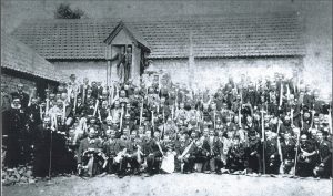
Westonzoyland was therefore the first steam powered pumping station in Somerset and its success was followed by the erection of a second steam engine, this time at Southlake. Further schemes followed and these are all fully documented and illustrated in Iain Miles’s excellent booklet listed below. It was not, however, until the Land Drainage Act of 1930 that a body was created that assumed responsibility for all the main rivers in the County. This was called The Somerset Rivers Catchment Board. Louis Kelting, (pictured below) later the Board’s Chief Engineer, wrote on this period

There was much preparation of grandiose schemes whose main virtue seemed to be that they invoked strenuous opposition from other authorities”.

 None-the-less, he achieved a great deal and in 1941 the first steam plant was replaced with a pair of diesel engine pumps. This was followed, once peace retuned after the war, with more stations being converted from steam to diesel and Westonzoyland was converted in 1950. The Westonzoyland diesel pump is now only used when conditions are bad, normally for 2-3 weeks a year. But, like other diesel pumps in the area it is kept in working order in case of need.

The Westonzoyland Pumping Station today is also a museum and houses the largest collection of stationary steam engines and pumps in the south of England. The fact that so much is preserved is thanks to Louis Kelting who attempted to preserve the redundant steam pumps in their original buildings and, where not possible, stored them at the Old Allermoor Pumping Station.

In his booklet, Iain Miles comments that

“Even people living on or near the levels frequently do not appreciate the organisation, sheer blood, sweat and tears that have gone and are still going into keeping Somerset dry, and safe to live and work in.”

Perhaps those of us who listened to his talk have just a little more appreciation of this than we had at the start of the evening.                                                                                                                                                                                                   Madeleine Roberts


Further Reading:
“…Bogs and inundations….” by Iain Miles
“The Draining of the Somerset Levels” by Michael Williams


Artist’s Impressions of the Western Mendips

The first talk of the autumn was given on Wednesday 18thSeptember by David Bromwich. David, with his encyclopaedic knowledge of the SANHS collections, had put together a fascinating talk based on the illustrations of Somerset held in the Heritage Centre. He explained how, before the camera was invented and in common use, travellers had been in the habit of recording places of interest with sketches. He described how some, doubting their own skills in this direction, even employed professional artists. One such was the Reverend Richard Kay, Dean of Lincoln, who employed the artist Samuel Hieronymus Grimm to travel with him and to make an accurate record of his journey. In addition to this, some wealthy people commissioned art works for their own pleasure and built up what were to become famous collections.

Spargrove Manor, Batcombe, 1829; by John Chessell Buckler (Piggott coll.)

Two of these were John Hugh Smith Pigott of Brockley Court, and George Weare Braikenridge of Broomwell House, Brislington. Between them all, they have left a remarkable legacy of drawings, lithographs, prints and watercolours of Somerset covering the period from the end of the eighteenth century through to the end of the nineteenth.

The record left includes some pictures of buildings that no longer exist, such as Holy Trinity, Bridgwater and Holy Trinity, Wellington where today only graveyards remain to show that the churches once existed. Many illustrations, however, record both the exteriors and interiors of churches as they were before the alterations of the Victorian Period. Others show us buildings still recognisable but in the process of change such as the one of St Mary Redcliffe, Bristol, before the spire was completed. In addition to churches, there were domestic scenes such as a cottage interior at Oare on Exmoor, and several of wider landscapes. A picture of Bedminster High Street drawn sometime in the 1820s or 30s looks almost medieval and is certainly unrecognisable to the casual eye today.

The Avon Gorge with Rownham Ferry in operation featured twice and although still easily recognisable shows the gorge before the Clifton Suspension Bridge was built and at a time when there was an ocean-going schooner navigating the gorge. Likewise, a picture of the Iron Bridge, Bridgwater, showed ocean going vessels on the downstream side of the bridge. Taunton featured twice with a picture of the Market House and Taunton Parade and another of the courtyard of Taunton Castle. David was able to point out the features of the courtyard that still exist today as well as those that are long gone. Closer to home, David showed us a wonderful picture of Cheddar Gorge by Samuel Jackson and was able to point out that the figures in the foreground were not of locals but had been taken from Pyne’s Microcosm, a book of foreground figures for artists.

Finally, David was able to indicate the value of the collections to the modern day by listing the large number of publications that have used them such as the Victoria County History and Somerset’s Millennium Book.

Entrance to Cheddar, 1824; by Samuel Jackson (Braikenridge coll.)


The defence of the British Channel

THE DEFENCE OF THE BRISTOL CHANNEL IN WW2

Following the AGM on April 16th the last talk of the season was delivered by Chris Webster, co-author of ‘Somerset and the Defence of the Bristol Channel in the Second World War’ by Dawson, Hunt and Webster (SANHS 2011).

He began by explaining the strategic importance of the West Country and the Bristol Channel in the defence of the nation.  Maritime trade is of crucial importance to the maintenance of supplies and in 1940 a tenth of British imports were coming through the Bristol Channel ports. Somerset harbours, although relatively minor, take on a much greater significance if viewed from the perspective of forming the southern flank of an important waterway giving access to the ports of South Wales, the port of Bristol and a network of waterways leading to the heart of the Midlands. The early concerns were therefore to defend the sea ports and keep the seaways open.

In 1940 however, the Germans occupied northern France and suddenly the West Country, which, inland at least, had been seen as a safe haven away from London, became vulnerable to invasion. Efforts were made to second guess German intentions and attacks were feared from both sea and air. Somerset beaches were feared to be suitable landing strips for aircraft as well as being vulnerable to sea born invasion. The open spaces on the high ground of both Exmoor and the Brendon Hills could likewise be used for landing aircraft and for parachute drops.

Plans were hurriedly drawn up to thwart any possible German plans and the necessary defences were installed. These defences formed the basis of Chris’s talk.

The Bristol Channel was fortified by the construction of gun batteries at Lavernock in South Wales, Flat Holm, Steep Holm and Brean Down forming a chain across the Bristol Channel to protect the area upstream.

The beaches were all protected with anti-tank obstacles and barbed wire although little evidence of this exists today. Pillboxes were also built to prevent movement inland from the beaches and some of these still exist. For example one can be found on Dunster Beach.

Inland from beaches a series of ‘stop-lines’ was devised primarily as anti-tank devices to impede enemy movement. They connected a series of features such as waterways, escarpments and ditches that in themselves were an obstruction to movement and into them anti-tank obstacles were incorporated turning the stop line into a significant barrier. Many also included sufficient defences to prevent infantry activity. The two most important were the Taunton Stop Line and the GHQ Stop Line.

The Taunton Stop Line ran from Burnham-on-Sea south across Somerset and Devon to Seaton on the south coast and its aim was to prevent movement out of the West Country should the Germans have gained a stronghold in the west.

The GHQ Stop Line ran east from Burnham-on-Sea and was the more important of the two lines.  It was intended as the final line of defence to keep the invader from reaching London and the industrial heartland in the Midlands.

The focus of significant road networks such as Bristol, Taunton and Exeter also had independent anti-tank defences and were referred to as anti-tank islands. All roads into these towns were heavily defended with roadblocks to prevent their use by the enemy.

Airfields such as Yeovilton and Culmhead (Churchstanton) were built from which the area could be defended and these airfields were in turn protected both from land attack and from enemy airborne landings. Guns on the perimeter pointed both ways, into the airfield in case of enemy landings and out from it to protect from enemy tanks should that be necessary.

On Axbridge Hill, a relatively small plateau, a series of ridges was constructed to prevent aircraft from landing.

Bombing decoys or fake cities were set up to confuse the enemy and divert bombing raids away from important sites. Three types of decoy were designed a Q5, QL and SF. A Q5 decoy was a simulated burning city, a QL a simulated badly blacked out city and starfish or SF was a special fire site, an enlarged version of a Q5. Locally a decoy site exists on Blackdown where the ground surface was altered and illuminated to mimic the layout of the British Railway Network in Bristol by night.

Finally, preparations were made for non-fighting roles. These included the building of the Royal Ordnance factory at Puriton where explosives were made, the Hydrographic Office in Taunton that produced essential maps and the Reserve Depot at Norton Fitzwarren where ration packs for the army were put together.

There were also preparations made for the returning wounded with hospitals being established at Hestercombe House in the Quantocks, Sandhill Park at Bishop’s Lydeard and Musgrove Park in Taunton. R.A.F. Merryfield became the receiving station for wounded Americans.

This account represents only a tiny amount of the information imparted by Chris Webster in his talk and available in the book. But, the research published in the book preserves for all time the story of how Somerset prepared for an invasion and how, should the preparations have proved necessary, it would have resisted the advance.

In the event, the Germans had no invasion plan for the south-west. Their only plan, Operation Sea Lion, focused on an invasion in the south-east of the country.

The talk was well attended and attracted a number of visitors.

Madeleine Roberts.


The Severn Railway Bridge Disaster

The February talk on The Severn Railway Disaster was given by Paul Barnett, a maritime historian and former Royal Marine. Paul became interested in the bridge disaster when he failed to find documentary evidence to support the stories about the event circulating in the area. The research that he undertook resulted in an exhibition in 2010 to mark the 50th anniversary of the disaster. It also led to the erection of two memorial stones on the banks of the Severn, one at Lydney Docks and one at Purton.

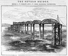
The bridge was constructed between 1875 and 1879 by the Severn Bridge Railway Company primarily to carry coal from the Forest of Dean to the docks at Sharpness, the Lydney docks being too small to cope with the growing volume of trade.  It continued in use for freight and some passenger services until 1960, the time of the disaster. It was designed by George Baker Keeling and constructed by Hamilston’s Windsor Ironworks Company Ltd of Garston, Liverpool. The bridge carried a single track railway and trains had to complete the return crossing from Sharpness to Lydney in reverse. It had been hoped that the line would attract tourist traffic as well as local passengers but seven years later the Severn tunnel was opened and, from early on, this threatened the bridge’s financial viability.

The bridge had twenty-three spans and over the years a number of vessels had collided with the piers as a result of the difficult conditions in the estuary. However, Paul wondered wryly whether the fact that the bridge wa
s covered by insurance could have had something to do with the number of collisions. The bridge was, after all, on the route of vessels heading for the breakers yard.

On 25th October 1960, two tanker barges, the Arkendale H and the Wastdale H collided in heavy fog near Sharpness. Both vessels had missed the entrance to Sharpness harbour and found themselves further upstream than they should have been. The result was that they had to battle against an incoming tide to regain the harbour entrance. The estuary narrows to the north of the harbour entrance and consequently the tide runs much faster at that point and has a back eddy. The skippers of the vessels lost control, their barges collided and as a result crashed broadside into pier 17 of the bridge. Part of the bridge collapsed hitting the barges. The Arkendale was carrying 191 tons of black oil, the Wastdale 252 tons of petrol. The result was a serious conflagration with five of the eight men on board the two vessels losing their lives. It could however have been even worse for, three days earlier, work had commenced on strengthening the bridge and, prior to the commencement of the programmed welding, the gas main which ran across the bridge had been disconnected. It was also fortunate that the six British Rail men employed to strengthen the bridge were off duty and busy listening to a boxing match at the time or they too could have been caught up in the disaster.

The accident left a 168ft gap in the 4,162ft. bridge and it remained in this state for seven years while decisions were made about whether to repair or demolish it. The decision had finally been made to go ahead with repairs when a capsized tanker caused further damage to pier 20 and the extra cost that this would have incurred made repair uneconomic. 
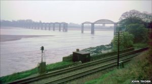
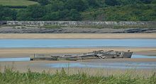
The decision to demolish was taken and demolition was completed between 1967 and 1970. Today all that remains to be seen are several piers on the embankment and, at low water, the wreckage of the two barges which remain on the river bed.

The bridge had been of a box girder design with only one other, the Tay Bridge, being of a similar construction. This too had failed leading to the Tay Bridge disaster of 1879.

During the course of Paul’s investigations some fascinating memorabilia came to light. The first was a set of thirty-nine glass sepia photographic plates that had been taken by Keeling in the early days of the bridge’s construction and had been used by him to publicise the project and to raise sponsorship. They had been rescued from a skip by someone who was fortunate enough to be aware of their significance. Only one other set of plates is known to exist and this is in the possession of the Cardiff Institute of Engineering.

The second find was a painting of the bridge measuring 14ft. by 4ft. It was an artist’s impression of the project prior to construction and this too had been rescued from a skip! It is known that investors in the project were each to be given a painting of the bridge and seventy-two watercolours were commissioned. Could this painting have been one of them? It seems possible.

In spite of a having a long journey back to Gloucester, Paul stayed for refreshments and spent time enthusiastically talking to members and answering questions.


Benefits, Brass and the Girtest Day Out

A lively and informative talk about Friendly Societies was given at the November meeting by Philip Hoyland. Philip explained that Friendly Societies were established at the end of the eighteenth century to enable the working man to cover the costs of medical care, any periods of unemployment nd to pay for funeral costs. In 1793 the Friendly Society Act was passed requiring Friendly Societies to be licensed and John Tidd Pratt became the Registrar based in London. Records show that by 1801 five thousand societies had registered and that four years later in 1805 the number had increased to ten thousand. By the beginning of the twentieth century six million people were using the system and funds had increased to £14 million. The friendly societies were the precursor of the National Insurance System and, at a time of increasing unemployment, had become very important.

So, how did the system work? Working men were eligible to join a Friendly Society between the ages of 16 and 35 but they could then remain members for life. They had to pay a subscription to belong and this varied from 8d to 1/- a week paid monthly. Fines were imposed on anyone who got behind with these payments. Members also had to pay for their own rule book and brass pole head and provide 4 gallons of cider at the first meeting they attended. The money collected was kept in a strong box by the treasurer and disbursed at times of need. Medical expenses would be covered where necessary and if a man was too ill to work he would receive sufficient funds to survive. At a time when the average weekly wage was 11/-, the average pay out would have been of the order of 6/-. A steward was appointed from among the club members and was required to make a weekly visit to anyone claiming sickness benefit. This ensured that there were no malingers but it was not a popular task and many preferred to pay a fine rather than perform it. On a man’s death, his widow would receive £2 to £3 to cover the cost of his funeral and members would also have a whip round for her. If a wife died a man would receive £5! Clearly his loss was considered much greater than hers. Friendly Societies would also lend money at no or low rates of interest and if calls on the funds had not been great for a period of time and money had accumulated there might be a share out rather like a dividend. Societies therefore performed some of the functions of a bank.

Societies, or clubs as they were often called, would meet once a month in a club room. This was often in a pub and everyone there would be entitled to 2d worth of beer. This must have led to quite a convivial atmosphere and possibly accounts for the poor reputation that club nights developed among the upper echelons of society. In spite of this reputation, members had to adhere to the rule book and standards were high. Rules varied between societies but misdemeanours such wearing a hat, playing certain games such as marbles or quoits, bringing a dog into the room, rioting or wrestling and even adultery could all incur fines which were then added to society funds.

Fivehead Club 1920’s

Once a year there was a very important Feast Day, Club Day or Walking Day as it was sometimes called, the costs of which were paid for out of funds. The men would gather in their club room dressed in their best clothes (no smocks were allowed) and wearing a sash and a flower or tutty in their button-hole.  They would then march to church beneath their club banner each man holding his club brass aloft on a long pole and they would be accompanied by a brass band. The church service would be followed by a procession round the area visiting all the big houses where further donations would be made to club funds. Following that, the serious business of the day began with a massive feast and much drinking. There was also a variety of entertainments to follow the feast. These might include dancing, games or even a fair.

Brass pole head        ©John Page

Philip had brought a wonderful collection of gleaming club brasses with him and the story of the brasses is an interesting one as the tradition of carrying brasses is not countrywide. They only seem to occur in Somerset and its surrounding counties and the origin of them is not clear unless they relate in some way to the ea
rlier guilds. Local brasses were made in the Bristol or Bridgwater foundries and the cost to each man would have been of the order of 1/6. This would have been quite a considerable sum of money atthattime. The design of the brasses was often related to the location of the club room.  If the location was in a pub then the pub name would be depicted. In Combwich the club room was at the Anchor Pub so the brass was in the shape of an anchor; at Kilve they met at the Hood Arms so the brass was a chuff and anchor – the Hood family crest etc. etc.

There were also female friendly societies, some of which in this area were established by Hannah More. How they were funded is not clear as subscriptions were only ½ d a week but Hannah More may well have contributed financially to them. On marriage a woman would receive 5/-, a pair of stockings and a bible. At the time of ‘lying in’ the benefit was 7/6.

The Friendly Societies continued in this form until 1948 when Aneurin Bevin who, for many years had been involved in his local variant of a Friendly Society the Tredegar ‘Sick Club’, introduced the National Health Service, or as he put it, “Tredegarised the nation”! Since then Friendly Societies have become less important but many still exist and still process to church once a year. Their function today is as fund raisers for charity.

Philip completed his talk by explaining how he kept his stunning collection of brasses in immaculate condition. It seems that a combination of Betterware paste and a product called Renaissance will preserve the surface without abrasion and the inevitable loss of surface decoration or the use of elbow grease.


What’s in a Sherd – a talk by David Dawson

What’s in a Sherd.

The autumn programme started this year with a talk from our president David Dawson. David’s research into the analysis of excavation pottery has the potential to revolutionise our understanding of the past and it is no wonder that his talk drew an audience from a wide area.

David started by describing in simple terms how to process excavation finds before turning to the more complex matter of identifying the form and fabric of a pot. These two elements of the process can help to determine not only age and function but also where a pot was made and how far it has been traded. Context, he emphasised, is everything. Without this it is impossible to make a valid interpretation.

Since the 1960s, the main method of identifying the fabric has been the ‘eyeball method’ preferably with the aid of a magnifying glass, although David rarely seems to need this. The late Professor D. Peacock of Southampton University improved on this method by taking thin sections which could be examined under a microscope and, while this was useful for identifying the temper or inclusions, it did not help greatly with the identification of the clay matrix.

The Peacock method was followed by the I.C.P. method or Inductively Coupled Plasma method using Atomic Emission Spectroscopy. This method does identify the minerals even those in the clay matrix but it presents the results as a list of tables which are not always easy to interpret.

The latest advance which David has been spearheading is called Quemscan and is being developed in conjunction with the Camborne School of Mines. Quemscan is an automated scanning system which has been used to analyse rock samples from the moon. The technique produces a visual map of what is in a sherd picking up the matrix as well as the inclusions and it also produces pie charts showing the percentage of every mineral that is present.

Results to date have shown some interesting correlations between the pottery found in Westbury-sub-Mendip and variously Wells, Chewton Mendip and Hope Wood, Ebbor Gorge. Common types appear to have been traded widely while others were made locally from local clay and local temper much as still happens in Africa today.

David also took the long view of pottery manufacture commenting on the Ceramic Revolution that took place between 1450 and 1650. During this period, ceramic imports increased bringing new forms and functions as well as new types of decoration. It is also possible that potters came too, fleeing religious persecution at home. Whatever the cause, forms and glazes diversified at this time and the country potter flourished until, in the nineteenth century, the process became industrialised and brick and tile manufacture evolved to meet the needs of a housing boom.

We have been privileged to hear David talk about this development while still in its early stages and shall wait with eager anticipation the further insights that are sure to emerge as more results become available.


Christon Church

Christon – the Church of St Mary the Virgin
The summer programme began on Sat
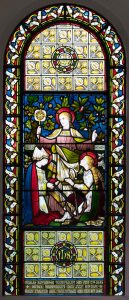
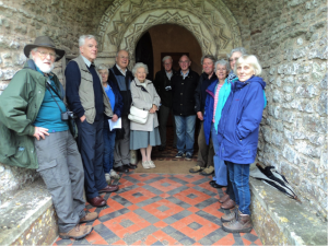
urday May 20th with a visit to Christon Church. Christon is a small village on the southern slope of Mendip and at the foot of Flagstaff Hill. It looks across the Lox-Yeo valley to Crook Peak and as people gathered many commented on the stunning setting and how tranquil and peaceful the valley must have been before the coming of the motorway.

The tour of the church of St. Mary the Virgin was led by the Reverend Ken Brown, former rector of the parish, who endeared himself to us early on by denying all responsibility for the wet weather with the observation that ‘Weather’s management, I’m only sales’.

Sales or not, he made an excellent tour guide, pointing out among other things, signs of Saxon herringbone masonry possibly dating from about 1050 AD and in the entrance the superb late Norman arched door opening with dog-tooth decoration and a Greek key-pattern design. See photograph.

Internally there is a 3-cell church: a nave, a bell tower and a chancel with the bell tower being the central cell. Between the nave and the bell tower and again between the bell tower and the chancel are further Norman arches both with the characteristic zig-zag decoration and the Greek key-hole design.

Medieval glass survives in the south window of the bell tower and four magnificent dragons, one at each corner of the tower, support the heavy groins of the vault above.

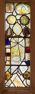
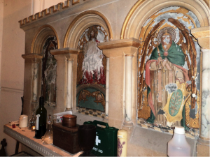
The chancel has been divided into two by a reredos to create a small vestry under the east
window but Reverend Brown unlocked the door into the vestry so that we could see the original altar with its painted panels. See photograph.

After the visit we sheltered in the porch until the rain had eased and then set off to explore the earthworks on Flagstaff Hill. We walked up the hollow way that is Flagstaff Road noting the house platforms, then out onto the hillside itself where early trackways were followed and field systems explored. The medieval ridge and furrow on the top of the hill was located and lynchets found on the north side of the hill that preserve early strip fields that may date from the Iron Age.

Detailed examination of the many house platforms and trackways was curtailed by the arrival of a new wave of rain and a hasty retreat was beaten leaving people to comment that a return would be welcomed but in better weather.

Some additional material by Elizabeth Friend.  Stained Glass windows – Joseph Bell studio, Bristol.

  • West window

    According to the pamphlet available in the church, the stained glass in the west window in the nave depicts Faith, Hope and Charity, as shown by the emblems held by the figures, and is the product of the Joseph Bell studio in Bristol.  From the same studio on the opposite north wall is a post-war memorial window depicting sergeant Durrant, a bomber navigator who was killed in a raid on Kiel canal.  He is shown in full kit with a map of the German port below.  His mother served as a VAD in London.

The east window is  a memorial to the Reverend Septimus Pope which is dated 1878 and is another product of the Joseph Bell studio

medieval glass

In the south wall there is a small window of medieval Somerset glass.  The eagle and book depicted there is the emblem of St John the Baptist.

Joseph Bell (1810-1895) founded his studio in the 1840’s and it continued to be run by his son (Frederick Henry Bell 1847-1899) and grandson (Frederick George 1878-1967) until 1923. Each generation was involved in the design and painting of the glass, with additional artists brought in to design and make commissions.  Joseph Bell & Son was later sold to Arnold Robinson, who had already undertaken commissions for the firm. After his death in 1955, Basil Barber, who had previously worked as chief cartoonist for Ninian Comper and had joined the studio in 1953, ran the firm until Geoffrey Robinson, son of Arnold Robinson, took over the firm in 1959. The studio closed after Geoffrey Robinson’s retirement in 1996.


Hidden Wedmore

HIDDEN WEDMORE

On Wednesday 19th April Hazel Hudson described to us some of the many discoveries in the field of archaeology and local history that have taken place in the parish of Wedmore. She herself has been involved in and often instrumental in the discovery of many of them since her first encounter with archaeology as a sixth former at Sexey’s Grammar School, Blackford in the 1950s. However, taking a chronological theme, she began her talk with the discovery in 1893 of dinosaur bones in the late Triassic deposits being quarried on the hill top close to the Mudgley Road. These bones proved to be unique in that they predate the more well known dinosaurs of the Jurassic and also in that they represent two dinosaurs that have not, as yet, been identified anywhere else in the world. They have been named Avalonia sanfordia and Picrodon herveyi after the men who discovered them. These bones are now on display in Taunton Museum and must surely be worth a visit.

Following this, Hazel described the discovery at Heath House of a variety of artefacts – two Bronze Age Palstaves, three Bronze Age torques and a number of amber beads. The last of these, the beads, must have come from the Baltic. Moving into the Neolithic, a trackway across the levels has been found near Blakeway Farm and this trackway c. 2500BC, made of hazel rods, shows the first evidence of coppicing yet to be identified in the country.

More than twenty sites have been located from the Roman period and Roman field patterns have been observed on the levels between the Isle of Wedmore and the Mendip Hills. Roman salt pans with their accompanying briquetage have also been found in the Westhay Moor area to the south of the Isle of Wedmore.

Evidence of the Saxon period is less clear but in 1853 Tucker Coles discovered a Saxon pot in St Mary’s church yard containing over two hundred silver pennies. Declared treasure trove, most are now in the British Museum but a small number can be found in Taunton Museum. The coins were minted in Lincoln and have been attributed to the reign of King Canute. In 1989, a Saxon ring dated to 5-600 AD was also discovered near the Cheddar Road. The ring consisted of strands of copper alloy wire twisted together. Hazel has a copy which she wears regularly but the design is so charming that gold copies are now made in Wedmore.

Moving to the Norman period, the area seems to have been favoured by the church hierarchy. The site of a Bishop’s Palace has been located and excavated in Blackford and it has been suggested that it was demolished in the late 1300s because it was thought to have been too sumptuous. A grand religious establishment has also been found at Court Garden in Mudgley. First recorded in 1176, it is believed to have been built in the 1100s and to have belonged to the Dean of Wells. Pottery has been found on the site from the twelfth through to the fifteenth centuries. A piece of slate has been found that has musical notation inscribed on it, possibly dating from the 1400s. Is this another first for the area, I wonder?

Other exciting locations include Fernhall Farm, Mudgley, which has shown evidence of occupation from the Mesolithic through to the Present Day and the Old Vicarage, Wedmore, with evidence from the Roman Period onwards. Gog’s Orchard, Wedmore, has produced evidence dating back to the Iron Age including a Roman burial from the 2nd or 3rd century with, as a result, the need for the housing development there to be built on concrete rafts to preserve the archaeology beneath.

Finally, Hazel described a number of details about St. Mary’s Church, Wedmore, many of which had been first noted by Jerry Sampson. She concluded her talk with the observation that the site of the Manor House next to the church was most probably the location of King Alfred’s court in Saxon times.

But, perhaps our own thoughts at the end of her talk must have been to wonder at the extent of Hidden Wedmore that she had revealed to us and to speculate on the excitement and fun that she must have had over the years in helping to uncover it.

Madeleine Roberts