The Mapping of Somerset

Joe and Christine King

Another difficult talk to describe without the illustrations. Although all the maps had a function they were also very decorative and it is that which makes them very interesting to look at. I will put some example on the website.

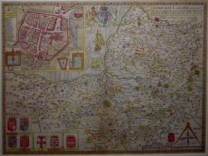
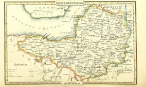
Joe started by saying how intriguing it was that Somerset was so well mapped and explained that this was because in the Elizabethan era they were very fearful of Catholic opposition to Elizabeth 1 and it was felt that her position was insecure. Her Chancellor, Lord Burghley was very anxious about the security of the throne and saw the value of having maps for defence and administration purposes.

He asked Thomas Seckford to arrange for the mapping of the country and he, in turn, asked Christopher Saxton to do this. Saxton had been a servant of John Rudd, vicar of Dewsbury who had, himself, tried to map the kingdom but couldn’t complete the task because it needed the assistance of all the great landowners.

He had been helped by Saxton and it was Saxton who the Privy Council asked to undertake the mapping of the kingdom and all the great landowner were instructed to give him assistance. He used a crude form of triangulation using the beacons, which were on all the high places and in five years had mapped the whole country. Somerset was one of the first places to be mapped and Joe showed the first published map of Somerset produced by Saxton, which is a fairly good representation of the county.

There are lots of decorative details on it, fish, boats, the coat of arms of Elizabeth 1 and also of Seckford which states “Sloth is the country’s bane”. The scale was of the military mile ie 1000 paces. The mile that we recognise today was fixed in 1592 but, as Joe pointed out, for the next 180 years or so many maps had a short mile, a middle mile and a long mile on them.   No-one knows why.

The people who made the maps were Flemish craftsmen who had come to England. The early maps were made on copper sheets, which were hammered flat and then the map was scribed on them. Names of course had to be done in mirror writing – very clever as Joe said. After about 300 copies of a map the sheet had to be scribed again.

The early maps showed various places such as Cheddar, Axbridge and Wookey Hole but it is the rivers that predominate. These and the bridges over them were, of course, the most important features to show given their significance for trade and travel. Roads were not shown until later and hills on the early maps looked like little mole hills. The depiction of hills was refined later.

Another main feature of these early maps was the inclusion of deer parks. Mappers had, of course, to be polite to important people but a deer park was also the site of an annual general muster for the villagers to prepare for war.

Given that Saxton had started with no idea of the shapes of counties, his maps were an extraordinary achievement. Editions of the maps, which were in black and white were produced for the next 100 years, although some were hand-coloured.

The next maps Joe showed were those of John Speed produced around 1610.

Speed was an historian who, when James 1st came to the throne was tasked with proving a direct lineage from James to the Greek heroes. No mean feat!

Joe showed Speed’s map of 1612. This shows, in one corner, a town plan of Bath complete with the heraldry of important people on it. It was the first map of the city and shows various details; baths, a horse bath, trees etc. It was very informative as a map and also shows the first reference to a tennis court. Perhaps the major change from previous maps was that it shows the Hundreds for the first time, which were, of course important administratively.  One question Joe raised was whether old maps were always correct. There were, of course, errors, but for many years the early maps were replicated by others and so the errors remained. As an example he showed Speed’s Wiltshire map, which shows two villages, now known as North and South Burcombe. On the original drawing Speed had written Quare (meaning query) next to North Burcombe and this was then engraved. For the next 162 years or so the “village of Quare” remained on the maps until the mistake was spotted.

Joe then showed a strange and unusual 1612 map by Michael Drayton who was a contemporary of Shakespeare. This showed women with trees growing out of their hair, ladies with cities on their heads and all manner of weird images.

Must try and find it for the website!

The Saxton and Speed were large and bound as books. In 1626 a map was produced by John Bill, which was of a size that could be put in a saddle bag and reflects the fact that people were moving about more and maps were useful to have with you. Knowing distances was also useful and the next map Joe showed was from 1625 and produced by John Norden who invented a table, which showed the distances between various places.

From then on, there were various innovations which I will just outline briefly.

John Ogilvy produced strip maps which covered the routes that people would commonly travel and which showed various landmarks you might see on your journey.

In 1676 maps were produced by Robert Morden which, for the first time showed roads. The first maps he produced were actually on the back of playing cards and these are now very rare collectors items. In 1695 Morden produced larger maps but interestingly these had no roads marked on them but did have 3 different mile scales despite the fact that it was over 100 years since the government had set the statutory mile we know today. These continued to be published after his death and the smaller plates were also produced with the roads marked.

Further changes to maps reflected wider social changes for example the addition of things of interest, which gave people more information about the places they were visiting. One example shown was of a map by Herman Moll, a friend of Daniel Defoe which included depictions of various antiquities .  Similarly John Gibson produced a small map with commodities such as corn, lead, woad, Bristol stone and lapis calaminaris (calamine) illustrated on it.

Strachey produced a vertical map of mining at Chew Magna showing what was going on underground. Although he was the first to do this he has received no credit for doing so and it was a William Smith who later produced similar maps and took the credit. Joe also showed a lovely county map done by Strachey with a plan of Wells on it complete with cathedral and houses.

New maps following the draining of the moors around 1769 showed that roads were then the dominant feature not rivers. Maps around this time were the last to be produced on copper and soon engravings on steel replaced them. These enabled the map-makers to have much finer lines and more detail.

Pinot 1842 showing roads, canals and railways

In the 19th century maps began to have a wider use, often reflecting economic changes. George III commissioned maps, which showed the agricultural use of the land for example. By 1820 mail coach roads were shown on the maps and around 1840 there were maps showing canals and later, ones showing railway lines also appeared. Such was the proliferation of railway building that maps were sometimes produced by the railway companies to advertise new lines that were never actually built!

County maps were, of course, still being produced and from 1812 some were in colour and Joe showed several examples. Many of them showed a lot of detailed information reflecting the Victorian desire for self-improvement.

Not all maps were decorative, however. Joe showed an example of what he called a “very miserable map” which was produced by William Cobbett.

The last decorative map was produced by Thomas Maule in 1838.

In conclusion Joe showed some strip maps, and some maps of Somerset where the county looked nothing like Somerset. One produced in 1742 made Somerset look like Africa. Finally, Joe urged everyone to keep a look out for old maps which do turn up occasionally in unlikely places. Some playing card maps recently made £1500 at auction!

An interesting talk and there was plenty to look at. Joe and Christine had a fine display of their maps around the room.


Somerset Parks and Gardens

Talk by James Bond.

By way of introduction James explained that Parks have changed character – originally deer parks in medieval times, then private parks attached to grand houses and only later were there public parks. Gardens on the other hand have also changed through time but also vary with social class

Beginning with an outline of how he got into this work he then traced parks and gardens back through time. It’s a difficult talk to describe relying as it does on a great many slides. I’ll try and find some links and pictures for the website

He started with a look at Green Beach Park in Clevedon (1887) explaining how the climate affected the planting and went on to comment on when plants were introduced. William Turner, Dean of Wells Cathedral wrote “A New Herball” in 1551 which, whilst relying heavily on earlier herbals, also included many of his own observations on plants in Somerset. This was the first printed herbal in England and Turner is acknowledged as the “Father of English botany” Henry Lyte of Lytes Cary also wrote a herbal in 1578 which was a translation of a French herbal translated from the Flemish original printed in 1554.

The next picture was of Hestercombe where the garden was re-modelled in 1903 by Edward Lutyens and Gertrude Jekyll on the orders of the owner E.W.B. Portman. The Great Plat, a sunken parterre, is a semi-recreation of an Elizabethan form with four geometrically laid out beds . The garden is fairly formal but not enclosed and has views over the surrounding countryside. Jekyll kept the planting scheme quite pastel in colour as she disliked Victorian plantings schemes of garish colour. James explained the layout of the garden and how Lutyens had linked the various elements, both formal and informal.

Lutyens also worked at Ammerdown which was originally surrounded by a deer park.   In 1901 Baron Hylton asked Lutyens to re-design the garden and he landscaped the area with a parterre leading to a more formal garden enclosed by high hedges

The next slide was of Wayford Manor an old house built in about 1600 but not completed at the time. In 1899 Ingham Baker employed Sir Ernest George to add a wing and Harold Peto was asked to re-design the garden. The top of the garden is quite formal but then drops down to a less informal woodland garden and Japanese rock garden. James explained that this was a good example of how gardens were moving from formality to informality and the varied planting also reflected the Victorian age of the plant collectors

There was, apparently, considerable debate at this time about whether formal gardens with strong architectural features were better than informal gardens. An exponent of the former was Inigo Thomas who designed the garden at Barrow Court, Barrow Gurney, for Henry Martin Gibbs. Thomas was famous as the illustrator of “The Formal Garden in England” and received many commissions after its publication in 1892. The garden show extreme formality, with a strong architectural framework, statues and formal planting.

By contrast the next slide was of the wild garden at Clapton Court. Here the planting looks very natural and features a wood and pond

James explained that one of the features in the Victorian era was the public park and showed a photograph of Vivary Park in Taunton, which was laid out in 1895 with its bandstand, fountain and impressive railings.

Another public park was Grove Park in Weston-super-Mare. The slide showed elaborate bedding schemes beloved of the Victorians. Although out of fashion now, James suggested that this form of planting lasted longer in public parks than anywhere else.

An example he showed from the early 19th was the garden at the Banwell Bone Caves with its Druid’s temple, pebble house, gazebo and Prospect Tower.

Moving back in time to the C18th James showed examples demonstrating the evolution of the private park. One example was West Quantoxhead where the park was expanded and developed at the expense of the village, and thereby leaving the church isolated. This was, apparently quite a wide-spread practice.

The parks were often deer parks which were designed to show off the wealth of the “nouveau riche” land owners, harking back as they did to previous times. They were a means of showing wealth and status. One example of this was Ammerdown House at Kilmersdon Thomas Joliffe, a clothier by trade, had married an heiress and created a park by uprooting hedges which James said was quite convincing unless you looked at the earthworks which show where the hedges were.

Another example shown was Orchardleigh near Frome, whose house was re-built and the gardens substantially altered in 1856. There is a very elaborate gateway designed so that the house is hidden from view and thereby demonstrating how important the house is. Inside the park, a large lake was created by “removing” some of the village and thus isolating the church on an island.

In the mid late 18th Capability Brown did some work in Somerset. His first commission in Somerset was at Newton St Loe in 1760. The park shows a characteristically Brown lake which imitates nature, sweeping lawns and artfully arranged trees. Brown was, apparently, very good at hiding things he didn’t want people to see such as the dams which formed the lake

Another job he undertook was at Burton Pynsent in 1765 where he designed a column for William Pitt as a memorial to William Pynsent the previous owner of the house who had bequeathed it to Pitt.

Before Brown, James told us, such informal gardens tended to have a much greater architectural component such as bridges and buildings but the houses were always linked to the landscape. Prior Park near Bath house has views to Bath and this was considered important. Pear Park at Hestercombe is another example of this era with a visible dam creating a lake and open vistas created by cutting through the natural woodland to show various follies and temples.

Other examples include Haswell Park near Goathurst which has some gothic features such as a rotunda on a hill, a temple of Pan and a Robin Hood hut disguised as a hermitage from which, apparently, a hermit served cucumber sandwiches!

The C18th was, according to James a period of transition and the garden at Marston Bigot was a good example. A drawing by Rene Parr in 1739 shows traditional features such as a formal garden and bowling green, typical of an earlier period but there was also a wild garden. This mix of classical elements with more eccentric ones has been referred to as Baroque. The garden was laid out between 1724 and 1745 by Stephen Switzer.

Another example of the transition from formality to less formal is Brympton d’Evercy near Yeovil. Here the garden had a very formal layout which was drawn by Johannes Kip, a Dutch artist, in 1772. Kip did a number of drawings which are like aerial views and, although dobt has been cast as to how accurate they are, James said that by looking at estate plans and the archaeology they have proved very accurate . The drawing shows a bowling green, long avenues of tree and formally planted orchards

Clevedon Court and Nether Stowey are other examples. A plan of the latter in 1750 shows elaborate planting, box hedges, and fish ponds. As James pointed out, many of these formal gardens have disappeared but can be traced back to the late Tudor period. Typical planting schemes and plans can be seen in “The Gardeners Labyrinth” a book written in 1577 by Thomas Hill under the pseudonym Diddymus Mountain.

Moving back in time to the Middle Ages, James showed a slide of the gardens at Montacute House. A survey of 1667 shows evidence of an Elizabethan layout and the basic framework was probably earlier than that. Cottlestone Manor also shows a courtyard and earthworks reveal a complicated terrace garden.

Many Elizabeth gardens have now vanished but James explained that a survey done in the 1960’s of large numbers of earthwork sites show where many gardens were which date back to the late C16th

Mick Aston did important work identifying some of these sites. For example the garden at Claverton manor near Bath which was laid out between 1580 and 1625, Parsonage Farm at Nether Stowey which also has earthworks showing several features which are similar to plans of other gardens of the age although they have no idea why they should have had such a garden there as it’s not thought to have been owned by anyone wealthy or important.

Another example was at Henshill Copse where earthworks show evidence of terraces and another at Low Ham which Mick first identified from the air. What is now an isolated church was once a chapel built in 1588 and there are extensive earthworks going up to it. Documentary evidence shows that a house was bought in 1588 by Sir Edward Hext who built a chapel there in 1623 and laid out a garden. In 1625 the house had passed to the Stawell family and in 1690 the mansion was demolished by Lord Stawell, who built another house lower down. The Stawell gardens were not completed when Lord Stawell died in 1692. They had cost £100K and had necessitated the sale of most of his other properties. Planning was, however, well underway when he died according to a letter of 1690 from Jacob Bobart the younger writing to Lord Stawell and describing the work then in hand.

Sometimes, James explained, maps also give us pictures of lost gardens. An example of a 1718 garden attached to a farmhouse reveals a parterre and shows that elements of the formal gardens did sometimes move down the social scale

In towns, gardens were very likely to retain some degree of formality because of space. A 1735 drawing of Wells shows gardens divided into formal patters and in another example at 4 The Circus, Bath, a Georgian garden layout was revealed when they dug under the Victorian spoil.

There are very few medieval gardens left but there are many mainly French and Flemish illustrations of gardens which drew a lot from the Arab world; ideas being picked up during the Crusades. Most were enclosed behind high stone walls with locked gates. Inside the gardens were compartmented with a lot of trellis and there were parts laid out in rectangular and raised beds with clipped shrubs and a lot of climbing plants and fruit trees grown for their fragrance rather than their fruit.

Examples of English gardens are mainly of monastery gardens. At Glastonbury, the Abbot had his own garden and there was also a subsistence garden, vineyard, orchard, grass that was being grazed, and nettles were grown as a crop. Records show that in one year 2000 heads of garlic were grown in the vegetable plot. A resistivity survey done at the Carthusian monastery site at Witton shows that the cells lived in by the monks each had their own garden and there is a similar layout at Hinton Charterhouse.  At Court Farm, Wookey in the 1550’s there was a substantial garden including a 4 acre orchard all contained within the moat. Records of the 1460’s show that they grew saffron. It was the only crop they grew and was perhaps a speculative venture since none was recorded as being grown there again.

Castles such as Farley Hungerford also had gardens and there are examples of the remains of horticulture in smaller manor house gardens such as at Mere where the remains of a vineyard can be seen and at Mells.  Another example is Nether Adber, a deserted medieval village.

Surviving flora is difficult to find but at Steep Holm there are some peonies which are thought to have been introduced by Augustinian monks although they were not documented until the C19th  Wild garlic is also related to the garlic which would have been found in medieval gardens.

James then returned to Deer parks showing a plan of 1687 of Marshwood Park, Dunster with a wild landscape of trees, boundaries, high banks and ditches. The overall shape of the parks was usually an oval shape, the purpose of which was to minimize the amount of paths around it and maximize the internal area.

Looking at Roman villas, James pointed out that these probably had very elaborate formal gardens and courtyards but very little is known.

He concluded by pointing out that although there were fashions in gardens there were always mavericks who did something different. He ended to laughter by showing the well-known garden at Cross with its elaborate topiary.


John Bunn, seaman 1789

John Bunn, seaman 1789.

Frances Neale gave us an excellent talk about John Bunn – and without the aid of PowerPoint!

Having spotted a chance reference to a John Bunn, seaman, in the Wedmore records, she and Hazel Hudson were intrigued. Why would a man from a small farming community be a sailor? Not impossible but it seemed rather unlikely and certainly worth further investigation and that investigation led Frances into areas of research she had never been to before.  Much to her delight!

Records showed that the Bunn family had been small farmers in Wedmore since, at least, the 1560’s when the existing registers date from and Bunn is a common name in Wedmore. Being small farmers who rented their land rather than owned it, there are very few records about them but the Parish has a very good run of poor law records and this was where they found the reference to John Bunn when she and Hazel Hudson were cataloguing the records (now in the Somerset Heritage Centre).

What they had found was a magistrates order written on 3 sides of paper. It was a standard order for the safe passage of a homeless person back to the Parish responsible for them. John Bunn, discharged seaman, to be conveyed from Isleworth, Middlesex to Wedmore.   What was unusual was the amount of detail it contained about the journey back to Wedmore and that it had been signed off by several people on the way. As Frances said, it made John Bunn seem like a parcel.

The magistrates order said that John Bunn, had been found “begging and lying about in the air” ie sleeping rough. His place of settlement was Wedmore in Somersetshire and the order instructed him to be taken back, with his pass, to the overseers of Wedmore. It was dated 30 November 1789.

The next page outlined the examination of John Bunn in which he swore on oath that he was born in Wedmore and all his family were legally settled there. He further stated that he had served in His Majesty

Yorke, William Horde; HMS ‘Eurydice’ at Sea; ©National Maritime Museum;

Navy on the frigate Eurydice and had been legally discharged from the Navy as an invalid. He could not write and signed with a cross.

The question was why was he in Isleworth? Frances surmised that as a navy man he would presumably have been put ashore in Woolwich or Deptford and if he couldn’t read or write then the logical thing might be that he would follow the river Thames and head westwards but only got as far as Isleworth before he ran out of money.

The next step was to consult the archivist at Maritime Museum, who was able to give Frances full particulars of the HMS Eurydice. In 1789 HMS Eurydice was patrolling in the Mediterranean under the captaincy of George Lumsdaine.

The muster list of June/July 1788 shows the ship was in dock at Woolwich and that John Bunn was number 46 on that list. The full complement was 140 men, who were later joined by 22 marines. It would appear that John Bunn had joined the ship at Woolwich having, perhaps, recently come off a returning ship. He gave his age as 45 years old which, as Frances observed, is old for an able seaman, most of the crew being in their teens to thirties. Frances had lots of details about the provisioning of the ship and the various activities she undertook. In 1789 the ship was in Gibraltar and on 31st March John Bunn was discharged as “unsuitable.” No explanation was given as to why. Apparently “unsuitable” is a term that covers everything except criminality or mutiny. After his discharge, he continued to be listed in the muster book but was then in Gibraltar Naval hospital and was given his due allowances of clothes, tobacco and pay until some time before November 1789 when he returned to England.  Details of why he was there were not available


1910 postcard of the Naval Hospital

Frances went on to describe the various places that John Bunn passed through on his journey back to Wedmore. a journey of 137 miles which took about 8 days. The details of his journey back, in a succession of formal handovers, was organised and paid for by local officials and was all detailed in the pass document. The fact that he was “conveyed” from place to place suggested to Frances that John Bunn had, perhaps, been invalided out of the Navy after losing a leg. This proved to be untrue as later records showed.

Back in Wedmore John Bunn was handed over to the overseers and appears in the accounts of January 1790 when he was given 7s in “illness” and 3s 6d for a spade. Clearly he was expected to work and had not lost a limb!

Frances detailed the various payments that John Bunn received during his time in the care of the overseers. He often required extra payments because he was ill and there are also medical records of him being attended to on several occasions for various complaints. It would appear that Wedmore looked after its poor very well; apart from regular payments made to him, he received shoes and clothing including “Canvas and Flannel for a truss “ and “Flanell for a Waistcoat.”

The reason why John Bunn was discharged from the Navy or had such a long stay in Gibraltar Naval Hospital remains a mystery but he lived on in Wedmore for 25 years after his discharge, often ill and unable to work for long periods, but cared for by the parish.

St Mary’s church Wedmore © Allen Goodwin-Hancock

He died in January 1814 and the burial register states that he was aged 75 years old and was buried in the churchyard paid for by the overseers.

That entry, therefore, revealed another small mystery. If John Bunn was 75 years old when he died then he would have been 49 years in 1788 when he joined the Eurydice and not 45 years old. As Frances said, he might have taken a few years off his date of birth in order to join the ship – who knows!

It was a fascinating story and, as ever with historical research, leaves a lot of questions still unanswered. But that’s the joy of it!!

Frances and Hazel Hudson have written their account of John Bunn, which will be published in the March edition of “Notes and Queries for Somerset and Dorset” a publication Frances highly recommends.


Lighthouse of the Bristol Channel

A talk by John Page

John started by showing a map of the lighthouses of Somerset including one at Hinkley Point, three at Burnham, two at Clevedon and one which is not in Somerset but which is very important for ships entering the Bristol Channel which is on Flat Holm. Although lighthouses are, of course, there as a warning to shipping and to aid navigation it is, as Daniel Defoe pointed out, the land with its rocks and sand banks and not the sea that makes a storm lethal to ships.  John explained that on old maps the Bristol Channel was actually called the Severn Sea. He then showed a video of a map which shows where the various lighthouses are in Somerset, a map complete with appropriate flashing lights. There are a lot of lights!

1721 drawing

John went on to describe some of the earliest lighthouses stating with the first one, which was on Pharos in Alexandria and was built circa 200BC. It was badly damaged by 3 earthquakes between 900AD and 1300AD and eventually became a ruin. It was operated at night by fires on top of it and by day by mirrors that reflected the sun.

The earliest lighthouse in Britain was at Dover and was built by the Romans. It was clear from reports that not everyone wanted to have lighthouses around their shores. The use of lights to guide shipping could, of course, also be used by smugglers who used them to wreck ships and steal their goods. An account in 1736 described one such case where a ship was driven onto Perrin Sands to steal the cargo.

In the early days it was not just lights that were used to guide ships. Other markers  such as hills, mills and churches; the white painted church tower at East Brent being one example.

He explained the difference between onshore and offshore lights with offshore lights being either on small islands such as Lundy or towers built on rocks.

Ilfracombe lighthouse              ©worldwide lighthouses

Using photographs, drawings and old documents John then described lighthouses in the Bristol Channel. The St Nicholas Chapel in Ilfracombe, he explained, is the oldest example of a tower and has been in use as such since the Middle Ages. In those days the light came from fires.

Hook lighthouse was also lit by fire and is situated at Wexford. It was built by monks in the C14th  and is still in use today.

As John explained, the increased trade into the Bristol Channel had made it inevitable that more lighthouses would be built.

St Anne’s Head built 1844  © Trinity House

The first lighthouse at St Ann’s Head was built in 1662 and was coal–fired. Charges to shipping for entering ports at this time could only be made when the ships were in port and a patent had to have been granted to allow charges to be made. At St Ann’s in 1662 the charges were only voluntary and not surprisingly they found that very few people paid them money and so they pulled down the lighthouse. Recognising the need for a lighthouse due to the number of ships being wrecked, however, Trinity House granted a patent for a lighthouse on the site and two towers were built in 1714, which were also coal-fired. The charge was 1d per ton of cargo for British vessels and 2d per ton of cargo for foreign ships. The current lighthouse was built in 1844.

Flatholm: Local people had to agree to the building of a lighthouse and also had to run them and apply for a Government patent. Merchants and trading gentlemen living in Bristol wanted to build one at Flat Holm but couldn’t get the necessary agreements until a ship carrying 60 soldiers was lost in 1735.

On December 3rd  1737 they received a patent and a lighthouse was built on the island. The island also had an isolation hospital. The light was produced from coal which came from Swansea but by 1753 the two men who had started it went bankrupt and Caleb Dickinson who had lent them the money to build it ended up owning it. John explained that the Somerset Record Office has a large number of documents relating to the family, which show the accounts relating to the lighthouse.

John went on to talk about the people who ran the lighthouses. The onshore ones had people living nearby but offshore ones were different. Here, there were normally 4 keepers per lighthouse. This was because in the early days there were only 2 keepers but on one occasion one of them died and the other was so worried that he might be accused of murder that he took the body and hung it outside the lighthouse in a bag to prove that the man had died of natural causes.

After that they always had 4 keepers per lighthouse, 3 on duty and one on leave. These would be a principal keeper, an assistant and a supernumerary or trainee, all of whom worked 8 hour shifts. Their duties were clear and included keeping a log, reporting on wind speed, visibility, barometric pressure and windforce which apparently they guessed by how it felt on their cheek   Since cleaning was also part of their duties they didn’t touch the brass rails on the stairs. Apparently no keeper would touch the rails!

Flat Holm  © flatholmisland.com

Reading from her account of her life on Flat Holm, John told us about Mrs Trezise who was there in 1926-9. At that time Flat Holm was considered the worst land lighthouse to work in but when her husband was appointed keeper there she was delighted. There were 9 people there at that time including the caretaker and his wife who looked after the hospital. In one year the weather was so bad that they couldn’t get provisions for nearly two months and had Christmas with no perishable food. To make matters worse one woman had a baby during this time and they nearly ran out of Nestlés milk!! In 1929 it was re-designated as a Rock Lighthouse and Mrs Trezise went to live in Swansea.

Mrs Trezise’s account can be read here

Instructions from those days included: lighting lamps and trimming them every three hours, maintaining watch, no bed or sofa was to be kept in the lantern room or watch room, everything had to be cleaned and polished and they should not cause any damage. They also had to either attend Church or the Principal Keeper had to conduct a service and deliver the sermon. Temperance, cleanliness and high standards of morality were also key demands.

John also talked about how the various lights were used and how they operated. The Mumbles lighthouse in 1794, for example, had two levels of fires. Lighting was by candles and bonfires until the introduction of lamps and clearly there were many dangers. After this they had oil lamps. Improvements came with the Argand lamp, which had an air flow up the centre which was more efficient than previous versions and was lit with heavy oil like whale oil. Later versions used kerosene. Improvements continued and soon came the introduction of reflectors at the back and large lenses at the front. Later still they used the Fresnel lamp which had rotating optics and was much more efficient.

Burnham beach lighthouse. Image taken from burnham-on-sea.com
Burnham tall tower. Image taken from burnham-on-sea.com

John went on to talk about Burnham lighthouses.  In 1895 a newspaper gave the origins of the Burnham Lighthouse and stated that legend had it that originally the “lighthouse” was simply a candle in the window of a cottage which a woman had put there to guide her husband home and due to its success was asked to do it permanently. Although this story has often been repeated, John said it was not quite accurate. Newspapers in 1846 reported that the first light was actually lit by a person on Stert Island, then an isthmus, to warn sailors of the dangers. Whatever the truth of the matter the first actual lighthouse was erected by the Rev David Davies of St Andrew’s Church, who paid for a tower to be built next to the church in 1801.   The number of vessels using the port increased after the lighthouse was built from 600 to 3000 and Trinity House took over its control from Rev Davies. A second tall lighthouse was put at the end of the channel and a third was erected on the beach because there was a blind spot. John explained that the one on the beach still works and that now all lights are remotely controlled.

In conclusion John mentioned briefly Watchet harbor light, Blackmore Point at Portishead which had a post in the middle to help rotation of the light and which was turned by a clockwork mechanism powered by a weight which had to be wound up every 2 hours, and finally Lundy which had a lighthouse situated so high that the top was often lost in the mist, so much so that another lighthouse had to be built lower down.

At which point time ran out. It was a fascinating story and clearly much more to be told.

2016 Excavations at Beckery

We had a very interesting talk on November 15th from Richard Brunning about the recent excavations at Beckery, the site of a medieval Chapel.

He started by explaining that Beckery would have been an island of hard geology sticking out of the flood plain. Today it is a rather curious landscape, with an industrial park at one edge, and a sewage farm at the other, but the centre line of the chapel lines up with Glastonbury Tor.

Speaking about the derivation of “Beckery”, Richard suggested that it might have meant either ‘bee-keeper’s island’ in Old English or is Irish for ‘Little Ireland’.

part of a 1965 tapestry in St Mary’s Catholic Church, Glastonbury

There are numerous legendary stories linked with Beckery. Medieval writers told of a visit to Beckery by St Brigit who visited the island in 488 AD and is said to have left behind some items including a necklace, small bell, a bag and some weaving implements. These relics were displayed in the medieval chapel named after her for pilgrims to view. King Arthur was also said to have visited the site and allegedly saw an image of the Virgin Mary. Although the former is possible, Richard suggested, that the latter was probably something made up by Glastonbury Abbey for publicity and financial reasons.

The site was first excavated by John Morland in 1887-1888. This found the remains of two chapels, a smaller Saxon timber chapel built around 700 AD and a larger Norman chapel which replaced the former and which was built around 1000 AD and enlarged in 1290. They also found the walls of what was thought to be a priest’s house and 6 graves with human remains. The location of the bodies seemed to confirm that the chapel had indeed been built in two phases.

©south west heritage trust:  Aerial view of the site showing the remains of two phases of stone chapel, the larger, outer walls being from the later chapel. The graves were underneath and outside these chapels. Four of the excavated graves are visible as disturbed patches of soil

The site was re-examined in 1997-8 by Philip Rahtz. This excavation uncovered further evidence of buildings on the site, which confirmed that a later chapel had indeed been built around the earlier chapel. They also found an extensive cemetery of 63 bodies. One grave was lined with slabs and there were post holes nearby indicating that it was of some significance and it appeared that the first timber chapel had been built around this.   They also found some human remains below the foundations of the Chapel indicating an earlier site.

Almost all of the bodies were of adult males, leaving little doubt that this was a monastic graveyard. The only exceptions were two juveniles who may have been novices and a woman who may have been a patron or a visiting nun. In those days radiocarbon dating was in its infancy and the results showed that the bones were dated between 600-1000 AD. This led Rahtz to conclude that this was a site of a late Saxon monastery.

The conclusion was that wooden building had been replaced in the C11th by another Chapel, which was then re-built in 1291 with a Priest’s house. In 2004-6 a resistivity survey by Beth Francis revealed the presence of a third building and geophysics revealed the possibility of an enclosing ditch.

The recent excavations at Beckery sought to extend the dig beyond that undergone by Rahtz and it confirmed the presence of a third building and found evidence for a fourth. It also showed that there was a wall that went far beyond the chapels that Rahtz had identified. Richard suggested that the stone from this wall could have been taken and re-used elsewhere after the dissolution of the monasteries.

© south west heritage trust:  David and Madeleine Roberts hard at work

The first trench was dug over the site of the enclosing ditch in which Iron Age pottery was found as well as a variety of animal bones which have been dated c.1020 AD -1155 AD.

The main aim of the excavation was to date the site more accurately. Although the skeletons found by Rahtz have been lost there were some remaining under the Chapel walls and the new excavation uncovered human remains on 5 sites. Seven individuals were dated from three largely complete burials, two partial burials that had been badly damaged by the foundation trench for one of the medieval chapels, one person represented by a single extra leg bone in one of the complete graves and a jaw fragment from the 1960’s backfill. One was of a male of about 167cm, which showed a fracture in one arm and teeth which were very worn but which showed few cavities. Isotope analysis suggests that they had a meat rich diet although the last individual dated had clearly had a more vegetarian diet and showed similarities with bones found at Glastonbury Lake Village.

© south west heritage trust: Excavation of adult male over 45 years old. 

Radiocarbon dating found that the earliest bones were from between 406 AD and 544 AD, which predates the conquest of Somerset by the Saxon kings of Wessex in the 7th Century. Later bones found were dated from about 618 AD – 710 AD and suggest that the monastic use of the site may have ended in the later 9th century when Somerset was attacked by Viking armies.

These dates provide the earliest archaeological evidence for monasticism in the British Isles. There were earlier sites in France but these findings show that this may have been the earliest monastic site in the UK and pre-dates Glastonbury Abbey. Richard suggested that the ancient origins of the Beckery site may explain why later medieval writers linked it to figures such as King Arthur and Saint Brigit.

There were many interesting pottery finds in the site. There was a lot of Saxo-Norman pottery circa 950 AD -1150 AD, Iron age pottery and lots of animal bones dating from C12th – C16th some of which were found in a new building identified on the site which may have been used for stabling.

Further isotope analysis is planned in order to try to determine if the monks were from the local population or if they had come from further away.

 In conclusion Richard said that the monastery could have been there when St Brigit visited the area. Imported medieval pottery found there suggest that it was of high status and Richard suggested that this might mean that the the monastery had a secular power base before the Anglo-Saxon conquest of Wessex which might have led to its destruction and its replacement by a Chapel. More work needs to be done but the findings are very significant for the history of the area.

SS Great Britain: from launch to re-launch

We had a very interesting talk on 18th October from Ian McCaskie (a visitor services volunteer) about the SS Great Britain. The bare bones of the history of the ship’s launch to re-launch is fairly well known and details are on their website, (www.ssgreatbritain.org) but the extra details Ian gave us were fascinating.

He began by outlining the historical context. In the 1830’s steam engines had an enormous impact on the way that we were able to travel on land and water. A lucrative contract was on offer for the provision of 4 wooden paddle steamers to carry Royal Mail from England to America. Cunard was expected to tender for the contract but a rival company was set up to compete for 
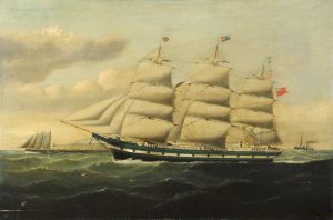
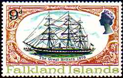
it; this was the Great Western Steamship Company and the directors decided to appoint Isambard Kingdom Brunel as their chief consulting engineer. Although Brunel had never designed a ship before, he was asked to do so on the basis of his work with the Great Western railway.

In the event he delivered only one wooden paddle steamer. This was “The Great Western” which was launched in 1837 for the Atlantic run and there is a plaque to it on the side of the M Shed museum in Bristol. In his lifetime Brunel built only 3 ships, the third one being the Great Eastern, which he built in London and which laid the transatlantic telegraph cable

fitting out in the Cumberland Basin in 1844

When it came to designing his second ship, Brunel started to think about how it could be improved. Up until then all ships had been made from timber but Brunel realised that a timber construction had limitations. It limited the size of the ship and because of the density of wood it was heavy and therefore slow. Around this time a coastal vessel called the “Rainbow” came into Bristol, which had an iron hull that made it much lighter and therefore faster in the water. Brunel suggested to the directors of the Great Western Co. that their second ship should have an iron hull and they agreed.

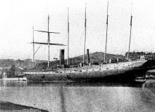
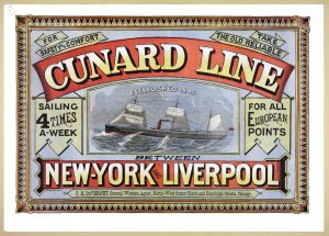
Although the contract for the Royal Mail to the US was subsequently given to Cunard the company realised that iron ships were the way forward.

Brunel had observed from building the Great Western that the propeller worked unevenly in the open seas and so, having seen another ship, the “Archimedes”, which came into Bristol at this time and which had a screw propeller, he designed his second ship with a screw propeller.  The SS Great Britain was, therefore, the first ship with an iron hull and a screw propeller and was then the biggest, fastest ocean-going transatlantic liner.

LAUNCH DAY

In 1843 it was ready to launch. Prince Albert, consort to Queen Victoria, attended the launch and was thankfully on hand to throw a second bottle of champagne at the ship when the lady designated to do it had missed with the first bottle!

an early voyage

Having undergone sea trials, the SS Great Britain then went from Liverpool to New York. There were berths for 250 first and second-class passengers on its maiden voyage but only 45 tickets were bought. It’s thought that this was because people were concerned about the safety of the vessel.
Wood floats and iron doesn’t!


The SS Great Britain made only 4 transatlantic crossings.  On the fifth voyage out they left Liverpool on a rather foggy night, missed the Calf of Man light and so continued to sail due west and ended up grounded in Northern Ireland on Dundrum Bay beach.  
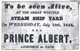
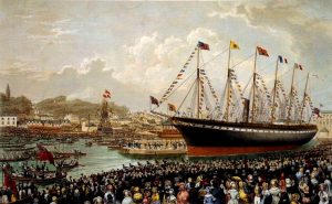
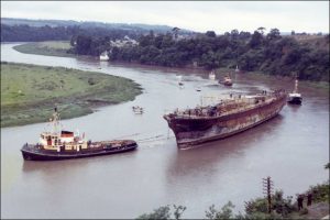
Brunel travelled over there to oversee the ship’s recovery. Fearing the approach of winter storms he made a breakwater around the stern of the ship which saved it from the worst of the winter weather but, although it was successfully re-floated and returned to Liverpool the following year, the cost involved had been enormous and the Great Western Steamship Company went bankrupt, forcing the sale of the SS Great Western and the SS Great Britain to Gibbs Wright and Co in 1847

From then of the ship had a fairly chequered history.

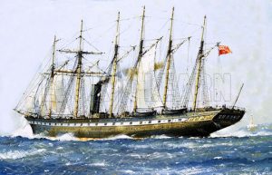
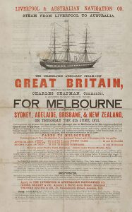
When gold was discovered in Australia in 1851, there was a sudden massive demand for ships to take people out there and the ship underwent a radical re-fit by the new owners Gibbs Bright & Co to become a 3 masted square–rigged sailing ship with auxiliary engines, which could do the voyage non-stop from Liverpool to Melbourne. In 1852 they carried 700 passengers. It cost 70 guineas (equivalent now to £5000) to travel to Melbourne first class and even in steerage it cost the equivalent of £1500 in today’s money. The journey took just 2 months.

A record of a trip in 1860 reveals that they also took a lot of live animals including 38 pigs, 2 bullocks 30 turkeys, 133 sheep, 400 geese, 420 chickens and 300 ducks and a dairy cow!

In the 1850’s the ship was requisitioned by the British government to take troops to the Crimean war and also to the Indian Mutiny and in 1861 it took the All England cricket team, including W.G. Grace’s brother, to Australia.

Passenger diaries have revealed what they did on board during those long trips: they played board games, sang, played music and even had their own newsletter called The Great Britain Times which has been an 
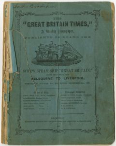
invaluable resource in piecing together what life was like on board.

Passengers on these voyages were always segregated by class and gender with males and females being separated at either end of the ship and with families and married couples in the middle. Clearly this didn’t always work to plan!!  In one woman’s diary she reveals that a certain Mrs Hodgson in First Class became “rather familiar” with a “rather shady man” and all the ladies “cut her” and she was referred to as a “lively woman” by the sailors.

In a honeymoon diary the writer says that there was an enormous amount of food consumed which was of excellent quality. Apparently they had breakfast at 9am, lunch at 12, dinner at 4pm, and tea at 7.30. The menus were very impressive!

J.M.Hardwick’s diary entry on 26 August 1852 recalls :
“…dinner which was first rate, quite such as you would get at the best hotels: soup, grouse, pigeon and veal pies, pork, ham and other meat dishes, sundry puddings and tarts and jelly, blancmange, cheese, celery and after all a dessert.”

Clearly all the passengers ate extremely well, although there were also reports in the diaries of a lot of sea-sickness. And there were a lot of rats!! One woman in first class says that she had seen rats in her cabin and reported that one woman had her toe-nails bitten by a rat.

By the late 1870’s the ship had been round the world over 30 times and had transported 16000 emigrants but the demand for trips to Australia was diminishing and Gibbs Bright laid the ship up on the Mersey.

crew members in San Francisco c.1883

In 1882 due to a demand from America for high-grade coal, Antony Gibbs & Son, bought the ship, stripped out the engines and the passenger accommodation and converted the ship to a windjammer cargo ship. As Ian pointed out, it seemed that, technologically, the SS Great Britain had gone backwards from her days as a great transatlantic liner.

Worried about the strength of the hull, once everything had been stripped out, the owners covered the iron in pine planking and soon it was taking coal from Penarth in Wales to San Francisco via Cape Horn. They made two round trips but on the third trip out, in 1886, it was damaged in a storm going round Cape Horn and was taken to the Falkland Islands where they hoped to repair it.

stranded at Sparrow Cove

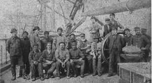
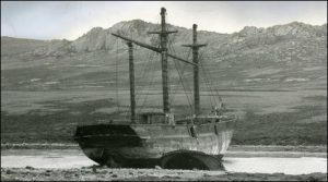
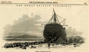
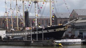
The cost of repairing the ship  was considered uneconomical and so she was sold to the Falkland Island Company for £2000 where it became a warehouse primarily for coal, wool and grain and was moored at Port Stanley Harbour.  It remained there until it was so rotten that they moved it to Sparrow Cove in 1937 where it was scuttled.  Despite being abandoned, she still had some uses. In WWI she was used as a bunkering station and in WWII plates were taken off her to repair damage which had occurred to the HMS Exeter during the Battle of the River Plate.  Throughout her time at Sparrow Cove the children of the island greatly enjoyed her presence, using her as an adventure playground and picking mussels from the hull to take home for their tea.

In the late 1960’s Ewan Corlett (a noted maritime architect) wrote to the Sunday Times about the tragedy that this great ship had been left to rot and suggested she be brought home.  The Admiralty did a survey and thought it was possible to do so but that it would be expensive. A committee was formed under Lord Strathcona, which launched an appeal to save her and, in early 1970, Sir Jack Hayward gave the money to pay for the salvage operation.

en route from the Falkland Islands on the pontoon

The idea was to remove the 3 remaining masts and to float the ship on a floating pontoon and tow it back to the UK. It was found, however, that the islanders had a cut a hatchway in the middle of the hull to facilitate its use as a coal store and, after it had been scuttled, a crack had developed and there was an 18 inch wide split in the hull. Clearly they couldn’t re-float her like that and so Lord Strathcona launched an appeal for mattresses and the islanders responded. Twenty mattresses were cut into strips which divers then jammed into the crack. Concrete was also used to repair the split, air was pumped into the pontoon tanks and  in the spring of 1970, ready to embark on the 8000 mile tow back to Bristol.

The ship was taken to Avonmouth and remained on the pontoon for 49 days while they made her water-tight by bolting steel over the cracks so that she could come off the pontoon.

coming into Bristol from Avonmouth

On July 5th 1970 she went from Avonmouth to Bristol where 100 thousand people watched her arrived. Many were astounded that such a rusty old ship was being brought back!! For the first time in her life she went under the suspension bridge and arrived at St Augustine’s reach. The idea was to put her back into the dock she had originally been in, but they had to make sure that the tide was high enough for the keel to be clear of the sill of the dock and on July 19th she made it. The keel cleared the sill of the dock by 7 inches and the ship was heard to sigh with relief. Apparently!!

Ian pointed out that the date July 19 was a very significant date in the history of Brunel and his ships: the Great Western was launched on that date in 1837, the keel of the SS Great Britain was laid on that date in 1839, the SS Great Britain was launched on that date in 1843 and on that date in1970 she got into the dock on her return from Falklands. A strange coincidence.

On her return the ship was in a very poor condition and Ian showed us several pictures of before and after the renovations.

There were of course problems. When the pine cladding was removed they found that below water line, where she had been sitting in salt water for so long in the Falkland Islands, the hull had started to corrode due to the presence of hygroscopic salts and they were warned in the mid 1990’s that if nothing was done the lower hull would essentially be eaten away and the ship would need to be scrapped. Fortunately Cardiff University designed a dehumidification system which effectively encloses the lower part of the hull and passes dry air into the space and keeps the moisture content of the air around the ship below 20%

So far this seems to be working well but is expensive to run!!

the ship transformed and as it is today

What they have done with the restoration is to reflect the various stages of the ship’s history. They have parts showing its life as a transatlantic liner with the first class promenade deck and first class cabins, the family and steerage accommodation on trips to Melbourne, and what it was like when it was a troop ship and a cargo ship.  A recent innovation has been the recreation of the galley complete with cat and rats! Computer images not real ones Ian hastened to add!!! They have also recreated a first class dining room from the 1840’s, which is used for functions and recently they have even managed to recreate smoke coming out of the funnel using water vapour, which Ian said was an amazing sight. They now get over 200,000 visitors per year.  You can also “Go Aloft” and climb up the rigging. Not something Ian is prepared to do, however!

artist’s impression of the new museum

Ian ended by telling us of a future plan. Brunel is acknowledged as one of the most influential British engineers of the past yet there is nowhere to learn the whole story about him and his achievements.   Two years ago the Great Britain Trust got funding to develop a national Brunel Museum and this will be sited next to the SS Great Britain. There will be a new build, opening in March 2018 and the old Dock Office of the Great Western Steamship Company will be restored to how it looked in Brunel’s time. They will also recreate Brunel’s drawing office. Visitors to the new museum will be greeted by a 2 storey head of Brunel which is currently under construction. Apparently visitors will go up to a mezzanine floor and enter the exhibition through one of his ears and exit through the other!!

What is particularly exciting is that they have access to a private collection of documents relating to Brunel the man as well as the engineer which has not been seen by the public before. Ian ended by showing two items from this collection which he particularly liked; a penknife with Brunel’s initials on it and a leather cigar case embossed with his initials and containing his last cigar!

Ian was an excellent communicator and gave a very interesting and informative talk The SS Great Britain sounds a good place to visit!!


Visit to Banwell Bone Caves

The last summer visit on July 9th was to the Banwell Bone Caves.

Starting with a lecture on the history of the caves, we were then gi
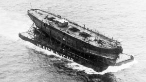
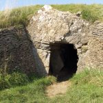
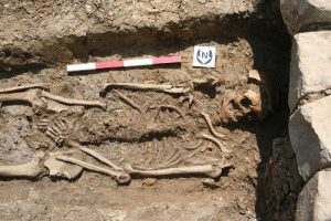
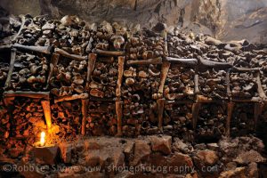
ven a guided tour of the cave where bones can still be seen. These Pleistocene animal bones were discovered in the early part of the 19th century on land owned by George Henry Law, the Bishop of Bath and Wells and, although many of them were removed, some  are still carefully stacked around the walls of the chamber.

At the time of their discovery there was great excitement as Bishop Law was convinced they provided evidence of Noah’s flood but it’s now agreed that they are of animals from the Ice Age thought to have fallen into the cave when the ice melted about 80,000 years ago. The bones are all of various animals similar to those that can be seen in the Arctic today including reindeer, bison, bear, and wolf.

Bishop Law employed William Beard to manage the caves and it was he who kept the caves open for several years after the death of Bishop Law.

We then walked around the grounds to see the Banwell Tower and the various follies which were built by Bishop Law and which have been carefully restored by the Banwell Caves Heritage Group which has worked hard to restore the site.
It is now classified as a Site of Special Scientific Interest (SSSI) and a Special Area of Conservation (SAC). .
The caves are not open to the public except by arrangement but well worth a visit.
Their website is banwellcaves.org.uk


Visit to Stoney Littleton long barrow

Members had an excellent visit to Stoney Littleton on 17th June 2017.

Entrance to the long barrow

David Roberts led the walk and gave us a detailed history of the long barrow and went the extra mile by providing detailed notes.  This is a brief summary of those notes.

Long barrows were constructed as earthen or drystone mounds with flanking ditches and acted as funerary monuments during the Early and Middle Neolithic periods. They represent the burial places of  Britain’s early farming communities and, as such, are amongst the oldest field monuments surviving visibly in the present landscape.

Where investigated, long barrows appear to have been used for communal burial, often with only parts of the human remains having been selected for internment. It is probable that long barrows acted as important ritual sites for local communities over a considerable period. Some 500 long barrows are recorded in England. As one of the few type of Neolithic structures to survive as earthworks, and due to their comparative rarity, their considerable age and their longevity as a monument type, all long barrows are nationally important.

 © English Heritage

Stoney Littleton is a Neolithic chambered barrow of the Cotswold Severn type. The defining characteristic of these barrows is their trapezoidal shape. Another common feature is a “forecourt area”. It is orientated NW-SE and is about 30m long, 2m high and 12.5m wide at its widest point. It is believed to have been formerly much higher.

The internal arrangement comprises a passage, with three pairs of side chambers and an end chamber. The length of the passage is about 13m and the height varies from 1.2m to 1.8m.

The first recorded opening of the barrow took place in about 1760 when the farmer, who owned the land, forced an entry through the roof to obtain stone for road mending.

The barrow was excavated in 1816 by John Skinner, accompanied by his brother Russell, Sir Richard Colt Hoare and his steward and surveyor Philip Crocker and a labourer Zebedee Weston, who probably undertook the heavy work.

They discovered human bones within the chamber and these are recorded as:

  • Leg and thigh bones and smaller fragments
  • From the east innermost side-chamber: four jaw bones, the teeth perfect; the upper parts of two crania (middle aged male and elderly female); leg, thigh and arm bones and vertebrae

From the west central side-chamber: fragments of earthenware vessel with burnt bones; bones of two or three skeletons.
Some of these bones are now in the Bristol Museum

The mound was restored by T.R. Joliffe in 1858, and further work as carried out on the site in 1938 by the Ministry of Works. There were later surveys in 1989 and 1995. Excavation and conservation work took place in 1999 and 2000.

Despite erosion over time, excavation and reconstruction, Stoney Littleton long barrow survives well and is now subject to statutory protection. It is to the credit of English Heritage that the barrow remains accessible to the public.

A tablet at the entrance records the Joliffe restoration:
“THIS TUMULUS, -DECLARED BY COMPETENT JUDGES TO BE THE MOST PERFECT SPECIMEN OF CELTIC ANTIQUITY STILL EXISTING IN GREAT BRITAIN HAVING BEEN MUCH INJURED BY THE LAPSE OF TIME, – OR THE CARELESSNESS OF FORMER PROPRIETORS, WAS RESTORED IN 1858 BY MR.R.T.JOLIFFE, THE LORD OF THE HUNDRED; THE DESIGN OF THE ORIGINAL STRUCTURE BEING PRESERVED, AS FAR AS POSSIBLE, WITH SCUPULOUS – EXACTNESS.”

The report of the Annual meeting of SANHS in 1857 states that, by means of a pecuniary grant, the Society was instrumental in carrying out timely preservation of the monument. It is unclear whether this report relates to the Joliffe restoration or was additional.


Family History – Fact or Fiction

On 15th March, Pat Hase gave an extremely entertaining talk on how to set about doing family history and some of the problems and pitfalls one might encounter.

She began by warning members it could become obsessive but could also be exciting and lead to a better understanding of social history.

She explained that one of the main difficulties with research was deciding what was fact and what was fiction. Her own grandfather told her wonderful tales when she was a small child, but few of them seem to have been rooted in fact and even when they were, they were much embellished. She thinks that many people start their research hoping they will be related to royalty or money but are more likely to uncover a child born out of wedlock, a death in the workhouse or another so-called scandal.

She told a delightful tale of a couple who got married, went abroad for their honeymoon and came back 6 months later with a baby. The explanation given by the mother was that it was hot overseas and things therefore happened more quickly!!

She warned that people should not believe everything they read on the internet. Americans are particularly guilty of passing on misinformation apparently!  People have built their whole family tree on spurious information. One had traced his family back to a Princess Margaret who had apparently married an agricultural labourer (which seems unlikely) and another reported family history of the Puddy family had traced their family back to a John Puddy who, it turned out, actually died aged 5 years.

She showed a photograph of herself as a baby taken in August 1939 pointing out that photographs can be a very useful source of information, not only about your own family, but also about social history as well.

She suggested that people should start with themselves and work backwards and that is was wise to follow the female line. After all, as she pointed out, the man named as a father on a birth certificate might not always be the father of the child! Interestingly it is now possible to get DNA testing done and this is always done on the female line. She also stressed the importance of speaking to relatives and friends as there are often things that your family didn’t bother to tell you but which friends of theirs sometimes know.

The 1939 register, taken as war began, is another important source of information giving, as it does, the ages and occupations of everyone at a certain address at that date. Anyone still living has been redacted from the register. As evidence of the usefulness of this she explained that on the register her grandfather’s date of birth was the 14th November, which is what he had been told, yet his actual birth certificate stated the 21st November. It turned out that, as births had to be registered within a certain time, his hadn’t been done within that period and so, to get round this, the registrar had simply added a week to his date of birth. This, not surprisingly, caused him much annoyance when he had to wait an extra week to get his pension.

Pat went on to encourage people to collect family memorabilia; diaries, family bibles etc. but there was a caveat to this. Apparently the Hase family bible has many wrong entries. It turns out that it had been copied by someone who had made mistakes in doing so. Her message, therefore, was to use original documents wherever possible as transcriptions might have errors. Surnames, for example. can vary. Researching the Hase family she has seen umpteen variations of the name. So beware.

Civil registration of births, marriage and deaths started in 1837 and the registration district was the Poor Law District so, for example, the Axbridge registration district actually includes 38 parishes.

Before 1837 you have to search Church records, which give baptisms, marriage and burials. Again, Pat made the point that baptisms do not always follow shortly after births. Some people were christened as adults and sometimes several children were baptised at the same time.

Another thing to be aware of is that between 1754 and 1837 marriages were required to be in church so many of those between non-conformists might appear to be childless, but this could be because the children would not have been baptised in the Church of England.

A useful source of information, she explained, are the census returns, which were done every 10 years from 1841 although a few were done earlier than that. In the 1841 census the information contained is, owever, limited.   It doesn’t give the relationships between family members, where they were born and adults were told to approximate their age to the nearest 5 years (although they could give their right age). Again there was a warning; the census returns can contain errors especially regarding age. This may be due to the person lying or transcription errors. Giving the example of her husband’s grandfather, he appeared to age very rapidly from 1841 to 1851 and on his death certificate in 1859 he had aged considerable yet again!. Transcription errors also often occurred on death certificates. On that of one William Hase, his wife appeared to have a different surname, but this was a simple error made by the person making the record.

Regarding where people lived, it is useful to look at the tithe apportionment maps which are available at the Record Office and which give the names of the landowner and the occupier of the land by tithe number around 1840. The Genealogist website has this information but you do have to pay for it.

Pat recommended drawing out your family tree to help see where people fit together. For families in this area she said that people did not always get married in the Parish of the bride and that some people got married in Bristol churches.

Newspapers are another source of information and the Western Gazette in now available from the Newspaper archive. She found some interesting accounts of the Hase family causing a disturbance in the papers and was quick to point out that she only married into this family!

She ended by going back to the tales her grandfather told her as a child. Apparently the Long family (her own family) was very important in Bristol; her great grandfather watched the riots in Queen Square, her great great grandfather owned a coal mine and her 3x grandfather owned 150 houses used on the London Stage Coach run. Going back another generation her 4x grandfather had entertained Garibaldi in his house when he visited Bristol.

On investigation it turned out the coal mine was actually sand pits and Garibaldi only stopped in Bristol for 10 minutes when the train stopped at Temple Meads.

Despite all her many warnings, her final message was to enjoy doing your family history but don’t believe everything you find.
Pat can be found every Saturday afternoon at Weston Town Hall and is happy to help anyone with their research, and their website www.wsmfhs.org.uk has lots of information on it to help as well.


The Winscombe Project

On January 18th, Theresa Hall gave a very detailed and interesting illustrated talk about the Winscombe Project which was started by Mick Aston.

She began by explaining the differences between this project and the one previously done by them at Shapwick.  In contrast to Shapwick, which was a nucleate settlement ie one village, Winsombe was an area of dispersed settlements. The medieval records show there to have been between 18 and 22 difference hamlets and a landscape which was more pastoral than arable. Although Shipham is listed separately in the Domesday book, it is thought that it was originally part of Winscombe since Shipham church paid money to Winscombe church every year in lieu of burial rights.

Theresa went on to explain the topography and geology of the area. Half of Winscombe is nestled within the Mendips and is a mix of different topography namely marsh , highlands, and some arable farm land.  In terms of the Geology there are two ridges of limestone hills, Mercian mudstone and ridges of Dolomitic conglomerate which run east to west through the valley and there is marshland in the north. There are several routes through the Mendips and it is probable that Winscombe was one of the main ones and therefore of importance.

 Pre-history and history: Looking at what they found.
A Paleolithic axe was found at Sidcot Playing Fields, which was about 250,000 years old. When, what they thought was a Neolithic hand axe was found in a garden in Sidcot about a foot below the surface, they were quite excited but, on examination by the Stone Axe group , this was found to be an adze and there were no adzes in Neolithic times. Even more intriguingly, it turned out that this one came from Polynesia. A second one was then found near Sidcot school with some medieval pottery nearby, but this was another Polynesian tool. They can only surmise that perhaps the school had a sort of cabinet of curiosities which was then broken up and dispersed.

They have found some Neolithic bits and pieces, but nothing really exciting.Nothing was found from the Bronze Age and little from the Iron Age, although they did find a possible iron age shard in Barton. Since the Banwell Hill Fort dominates the area they had expected to have found more than this and although it is thought that there may have been hut circles in the area they have, so far, got no evidence for this.

Wint Hill is near the parish on the north side of the valley and the major Roman find there is the Wint Hill Bowl dating back to the 4th century, originating from Cologne, which was found in the 1950’s. There are photos of the excavation in KJHL. The photographs show some skeletal remains, which were rumoured to have been put down a well by a suspicious farmer. Some of these bones are conserved in the museum and carbon dating suggests that some were from 430-610 and some from 660-810. They had presumed the bones were Roman but they are later than that and extend over a considerable time. It is suggested that they may be part of a Dark Age cemetery and that there might have been a monastic site in the vicinity of Banwell before the Saxon Minster was there, so there may have been a cemetery of an earlier British site on the hill . When the Church was built in Banwell the cemetery would then have ceased to function.

Roman remains associated with that settlement continued down the hill into the valley and were discovered when a pipeline was put in. There were several Roman buildings going down the hill alongside the pipeline and there are also bits of Roman pottery found at Barton and on the site of Star Villa, which is now in Shipham parish. On the Sandford side of the hill not much has been found but some fields have the name Blacklands which is a name associated with Roman times. They conclude that the Roman were in the area, but can not be more specific than that.

History.
Winscombe is first mentioned when King Edgar (959-975) granted 15 hides at Winscombe to Aelfswith. She was the wife of Aeltheah who owned much of the land in Wessex, and was a kinswoman of the previous King Eadwig, In other words they were an important and wealthy couple. Although they might never have gone to Winscombe they could have had an estate there which they could have used if the King was travelling around his kingdom and was, for example, visiting Cheddar or Banwell.   Aeltheah had a brother who was a monk at Glastonbury Abbey and the couple gave lands to the Abbey which included Winscombe, so that from this time Winscombe belonged to Glastonbury Abbey. The Domesday map shows the Banwell estate which belonged to the Bishop of Wells and it is thought that Winscombe was perhaps carved out of this estate. Theresa said that there is evidence that this estate changed ownership several times.

There are no parish boundaries for Winscombe and no charter boundaries although there are two nearby. Compton Bishop has one granted from the 10th century and Banwell from 1068. This latter included Sandford, yet Sandford was part of the Church lands belonging to Winscombe and therefore belonged to Glastonbury. They think that this might perhaps be because Harold had seized Banwell (which belonged to Wells) and he might have arbitarily decided to take Sandford as well, but it does go back into the hands of Glastonbury later.

At Domesday, much of Winscombe belonged to Glastonbury but there were also people holding knights fees. There is an area around Woodborough of 2 1/2 hides belonging to Roger de Courseulles who also held Shipham. In the north of the parish in an area around Shipham and an area around Nye there is 1 hide and 1 virgate of land held by Ralph Tortemain or Crooked Hands, who held other lands as well. Another half a hide for land at Barton was held by a man called Pipe and, as this is the only land that he owns at Domesday, it is thought he was maybe living there. Both Roger de Courseulles and Ralph Tortemain had their main residences elsewhere.

In 1197 following the death of the Abbot of Glastonbury, Bishop Savaric takes over Glastonbury Abbey as well as being Bishop of Wells. Although this had been allowed by the King the monks were, apparently, not happy. In 1215 they went to the Pope and petitioned for the lands to be given back to them and the Pope agreed. Despite this the Bishop decided to keep four estates at Blackford, Winscombe and 2 others. Later, Bishop Jocelin re-arranged the cathedral Chapter and he gave Winscombe to the Dean and Chapter of Wells and it stayed with the Dean and Chapter until the 18th century when parts began to be sold off. Had it stayed in the hands of Glastonbury then it would have gone into private hands at Dissolution.

Following the retention of land by Bishop Savaric the monks of Glastonbury continued to take court action against the Bishop over the lands he had retained.  This is evidenced in an account of a duel recorded by John Seldon who wrote a book in 1610 about dueling in which he quotes a deed which refers to the battle between the Abbot and the Bishop over the land. The Abbot appointed a fighter to act on his behalf who was given 10 marks of silver with a further 5 more promised if he won the battle. The account states that on the day of the duel the opponents were barelegged, bareheaded and bared to the elbow and held a red staff of an ells length. We don’t know who represented the Bishop nor do we know who won but it was presumably the Bishop’s man as Winscombe remained with the Dean and Chapter.

There was one tenant of Roger de Courseulles in the 13th century, Henry Lovestheft, who belonged to the Bishop’s Court and he apparently gave some land away to Woodspring Priory, some to Minchin Buckland and some for the building of St Augustine’s Abbey in Bristol. Although he was only the tenant of the land one can only assume that he did this with permission.

Methods.
A lot of work was done by Maria Forbes and Mick Aston.
Various surveys were translated including surveys of the Parish dated 1572 and 1650 of the Dean and Chapter lands.   A survey of the Manor of Sandford which was done in 1540 for the Seymours was translated with the help of Frances Neale. Martin Ecclestone also translated the Court rolls and Compotos rolls

Within the Compotos Rolls and court rolls from 1360-1540 there are all the inhabitants on Dean and Chapter land listed by their status. These followed a pattern, so every year you can follow the inhabitants through time ie 1290-1640. The place they lived in is appended to the names of the people so that many of the people listed can be traced through time. As Theresa pointed out, this is easier where there are separate hamlets rather than a village. They hope that test pits on these houses might reveal status changes through looking at the pottery that comes out of the pits

She then went on to describe some of the articles that have been written about the project, which include one that Mick Aston wrote about farming within the Parish and one about the woodland. There is an interesting reference in the woodland records which states that in 1342, 5s 6d was paid for the bark of 16 oak trees which went to St Cuthberts Church in Wells and there are references to this being carted there. This wood can now be found in the chancel roof of the church.

They also looked at various maps of the Parish although there are not a huge number of them. There is a 1792 map of Winscombe made by William White for the Dean and Chapter of Wells. Interestingly this has lots of blanks on it which refer to the parts that the Dean and Chapter didn’t own. These are the areas which equate to those held by the Knights at Domesday so, for example, an area of Sandford which is blank is thought to be the lands held by Ralph Tortemain.

Theresa showed a map of Sandford, done by Mick Aston which shows the land not owned by the Dean and Chapter. This was land owned by individuals who clearly had strips of land intermingled with strips belonging to the Church.   Theresa pointed out that this might be important in understanding the development of the parish.

Edward Seymour the brother of Jane Seymour, owned Sandford Manor which was part of the Cheddar Estate. He had to go to law to get it, however. It had been previously been owned by the Lisle family and, at this time, held by Arthur Plantagenet the illegitimate son of Edward IV. Apparently Edward thought the land was rented by Arthur who thought differently and the matter went to Cromwell to adjudicate. It took 8 years to settle with Cromwell deciding in favour of Edward once Jane became queen.

Theresa showed a slide of Nye Farm which is on one of the islands in the marsh which belonged to Edward Seymour.   There was a moated site at the end of the island which was the main residence of whoever was renting Sandford manor. They have found some earthworks at this site which they will investigate in due course.

A map found in a house in Wells shows Woodborough Common with winding gears drawn on it and it is thought that this was drawn up for the Dean and Chapter when they gave the right to mine to someone who lived in Shipham. They have found some lead weights there of the sort associated with mining.

Theresa showed more maps drawn by Mick Aston. One of the green shows a tiny remnant of land which has been cut off by railway line and appeared not to be owned by anyone. This has now been claimed by the Parish Council and now forms a little orchard garden.

There was also a map of the Lynch from the air. They have found evidence of burials at the western end and at the centre of the Lynch there was a windmill dating back to the 13th century.  Various other aerial maps have been done.

Another map drawn by Mick Aston is a reconstruction, which shows how meadowland could have been reclaimed from the marsh.

Building surveys were done by The Somerset vernacular group, which has looked at more recent houses.   As well as vernacular building there are a lot of Victorian villas, probably because Winscombe was thought to be a healthy place to live. Of particular interest is West End Farm in Barton which has a cruck beam that dates back to 1278. This is the date of the first the compotos rolls and it is thought that this is the earliest vernacular building in Somerset still lived in.

Techniques
Geophysics has been done and James Bond has done earthwork surveys.
They have done little field walking because of the amount of material it creates although they did look at a field at Max Mills and found some Roman bits.

Test pitting was the main technique they used..

At Tower House they found a lot of roof tiles. In the historical record this area is called Ford and there was free tenant called William Ford recorded, who farmed there.

They have done a total of 189 test pits of which 29 were in Sidcot. They have found some medieval bits from the central area and some smithing remains outside the meeting house. There were 2 smiths in the parish, one in Winscombe and one, who was a free tenant, in Sidcot.

29 have been done in Barton, the main arable area, but these have not revealed very much and not as much as in farms in the hamlets. An orchard site in Barton has revealed some jars and some Saintonge ware which is an import from France and usually only found in cities or on manorial sites, not in rural areas

Other test pits were done at the Lynch around the site of an old windmill.

At Woodborough Mill they have found some medieval material. The Mill was owned at this time by Henry Lovestheft who gave some land to the Church and was allowed in return to get the right to take the water from a spring which, when diverted, added to the water going to his mill. This water would have gone naturally to Max Mill. There was a 17th century court case because the owner of the Mill had a tenant at the time who had allowed a wall to fall into disrepair and this meant that the water then went to Max Mill. Although the people at Max Mill were quite happy about this there were clearly several arguments and threats of violence over the water, which culminated in the court case. Although we don’t know the result of the court case we can assume that Woodborough Mill won as they had the documentary evidence to support their case

Theresa went on to talk about the settlement of Wyke, the site of which is unknown. Mick thought he’d identified it in one of the fields in the Parish and they have done 3 test pits there. Although they have found no pottery, one pit showed evidence of something industrial and was, perhaps, an iron working furnace.

The Court area. In the test pits they have found fine ware from the 13th and 14th century, and coarse ware at the farm end. Outside the court they found no pottery. In the compotos rolls the people who have tenements are nearly all cottars so were presumably servants of the Court rather than farming for themselves.

To finish, Theresa described a Christmas card sent by James Bond to Mick Aston which imagined them in the future doing some penetrating analysis from their armchairs based on the whole landscape being digitised thus saving them all from going out into the cold and wet. An interesting thought!!

There are a lot of articles written about the Winscombe project written by Mick Aston and ones published by SANHS.

This is a link  to Mick Aston’s site

There are also several articles published by SANHS – just go to the SANHS site  and put winscombe project in the search box

Liz Friend